This practical guide for the Kjerag hike covers everything you need to plan a safe hiking adventure on one of Norway’s most iconic trails.
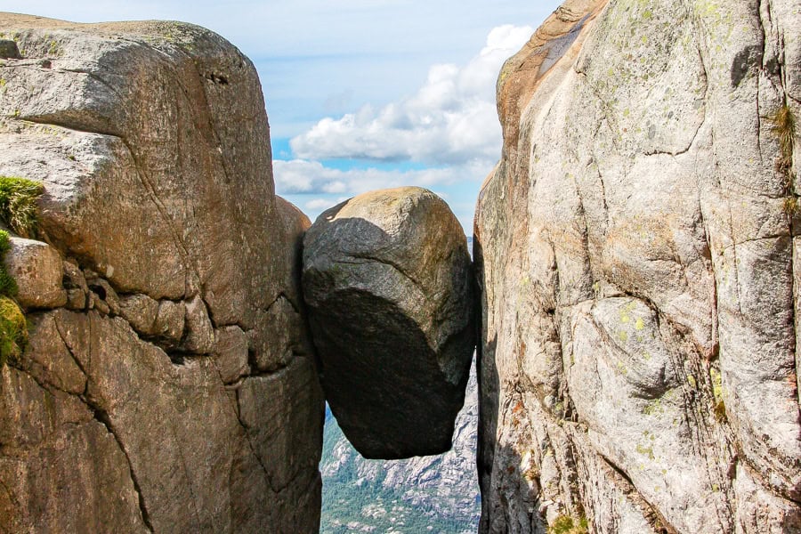
The Kjerag trail is one of Norway’s most iconic hikes, renowned for its uniquely thrilling summit – Kjeragbolten – suspended 984 metres above Lysefjord.
Aside from the boulder though, this is an extraordinary day of hiking, with truly epic views, steep and – I’ll be honest – challenging climbs, a sheer drop or two, and a massive sense of achievement when you make it to the top.
Kjerag Hike – Snapshot
Location: Kjerag is located on the southern side of Lysefjord in Rogaland, southwestern Norway. The nearest village is Lysebotn, around 7km from the trailhead.
Start & Finish: The trailhead starts and finishes at Øygardstøl near Lysebotn.
Distance: The hike is appx. 10km out-and-back.
Time: 5-6 hours, including breaks and time to queue for Kjeragbolten if you’re keen.
Difficulty: We’d rate this as a fairly strenuous hike, since it has three steep ascents with chains, rocky and often slippery terrain, and some exposed sections.
What’s in this post?
Preparing for a Kjerag Hike
– What to pack
– Best time to hike Kjerag
– Where to stay
– How to get to Kjerag
– Renting a car in Stavanger
What to Expect from the Kjerag Hike
– The Kjerag hiking trail
– Trail conditions
– Facilities
– Safety tips
– Our experience hiking Kjeragbolten
Kjerag Tours
– Guided hiking tours
– Non-hiking options
This post contains affiliate links. If you choose to buy through these links we may earn a small commission at no extra cost to you, which helps us to keep Two For The World running. Many thanks for your support!
Preparing for a Kjerag Hike
What to pack
Respecting both the environment and the weather is critical when hiking in Norway, so ensure you’re properly prepared with all the essentials for a safe and enjoyable hiking experience.
Footwear: With numerous steep sections, slippery rocks, glacier streams, and snow patches in places, you’ll want to be wearing decent hiking boots or shoes with good traction when tackling the Kjerag hike.
Clothing: Norway’s changeable weather, even in summer, means it’s always good to pack layers when hiking here. We had beanies, baseball hats, fleeces, rain jackets, gloves, and sun protection in our packs for our Kjerag hiking adventure.
Water and Snacks: We always carry as much water as we can for any long hike, along with snacks, which generally consist of trail mix or energy bars – but essentially whatever we can stock up on before the hike. We also prepared a packed lunch for hiking Kjerag, which we ate while enjoying the show of the brave souls stepping onto Kjeragbolten before us.
Camera: You’ll absolutely want to bring a decent camera if you want to capture that magic moment when you step out onto Kjeragbolten, as well as capturing decent, high-resolution images of the incredible scenery throughout the hike.
Best time to hike Kjerag
The main season for hiking Kjerag runs from June to September, when the trail is typically free of snow and the weather is most stable.
Outside of this window, snow and ice can make the trail dangerous or inaccessible. The local road to Øygardstøl, the trailhead, is also closed in winter and often doesn’t reopen until late spring.
July and August are the busiest months on the trail, especially during the summer school holiday period. We hiked Kjerag in July, and while we didn’t feel overwhelmed by the number of people along the trail, there was a long queue to step out onto Kjeragbolten. If you prefer a bit more solitude, perhaps consider hiking early in the day or later in the season.
Weather conditions in the mountains can change quickly, even in summer. Fog, wind and rain are common, and temperatures can drop sharply at higher altitudes. Always check the forecast before setting out and be prepared for a range of conditions. It’s also important to note that the trail, particularly the exposed rocky sections, and the Kjeragbolten itself, can be slippery after rain, so aim for a dry day if you can.
Where to stay
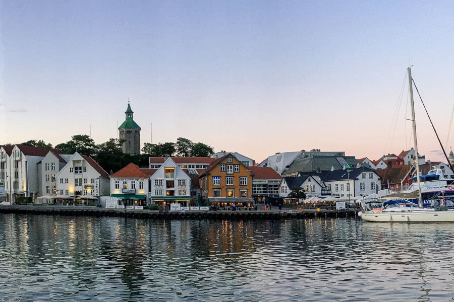
While there are a couple of guesthouse and camping options in Lysebotn, most people intending to hike Kjerag will base themselves in Stavanger – around 2.5 hours’ drive from the trailhead – due to its broader selection of stays and eating options.
We stayed in a comfortable studio at Bjørvika Apartments – Sirkus Renaa, an easy 10-15 minute walk from central Stavanger. There are a few options to choose from here, including studios and 1 or 2 bedroom apartments.
Other options that get consistently good reviews include:
- Good value: Cozee Central Apartments – clean and tidy | central location | comfy bed | well equipped kitchen
- Mid-range: Radisson Blu Atlantic Hotel – central location | gym and sauna facilities | clean, modern rooms
- Spend a bit more: Hotel Victoria – central harbourside location | spacious rooms | tasty breakfast | friendly staff.
Staying Longer? If you’re planning to spend a little longer in the area, or are visiting Stavanger as part of a longer trip, you might find our Norway road trip itinerary helpful.
How to get to Kjerag
Kjerag is located on the southern side of Lysefjord in Rogaland County, southwestern Norway. The trail begins at Øygardstøl, high above the fjord on the scenic Lysevegen mountain road.
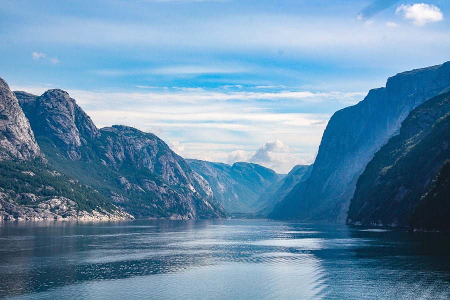
By Car: Our journey to and from the Kjerag hike trailhead was as much a highlight as the trek itself. To get there, we drove from Stavanger to Lauvvik (around 40 minutes) and took the car ferry to Lysebotn, a spectacular 2.5 hour trip along the length of the Lysefjord. From the ferry, it’s a thrilling drive up the side of the mountain along the switchbacks of Lysevegen Road.
It’s worth noting the car ferry timetable varies depending on the time of year, and you need to book in advance. You can find more information, including current timetables and booking links, on the Visit Norway website.
After the hike, we recommend looping back to Stavanger via the Fv500 and Fv450, a 2.5 hour (140km) journey that passes through some absolutely mind-blowing mountain-and-valley scenery. You can also take this route both ways if the ferry isn’t running or you can’t get a ferry ticket for the day you plan to hike.
By Bus: Between June and September, the Kjerag Express bus (run by Go Fjords) offers direct services from Stavanger to the trailhead at Øygardstøl. The journey takes approximately 3 hours each way and allows for around 6 hours at Kjerag. It’s 995 NOK for a return ticket and you can find more details, including booking information, on the Go Fjords website.
By Organised Tour: You’ll find plenty of operators offering guided tours to Kjerag from Stavanger. This can be a good option if you’d like to go with a guide and other hikers, or just have someone else organise the logistics. See our suggestions at the end of this post for popular guided tour options.
Renting a car in Stavanger
Whether you’re just visiting Stavanger or enjoying a longer trip through Norway, hiring a car is the easiest way to get around — especially if you plan to explore Norway’s mountains and fjords.
With decent road infrastructure and largely considerate fellow drivers, you’ll find road tripping in Norway a breeze. However, it’s good to know some of the key local rules and driving conventions in advance, so check out our guide to driving in Norway before you go.
We’ve always found the best deals at DiscoverCars and they’re our go-to car hire provider these days, with great rates and free cancellation should your plans need to change.
Booking your Stavanger car hire in advance will get you the best rates and widest choice of vehicle.
What to Expect on the Kjerag Hike
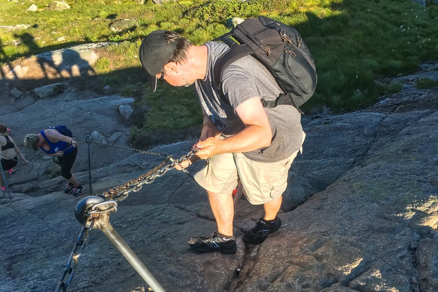
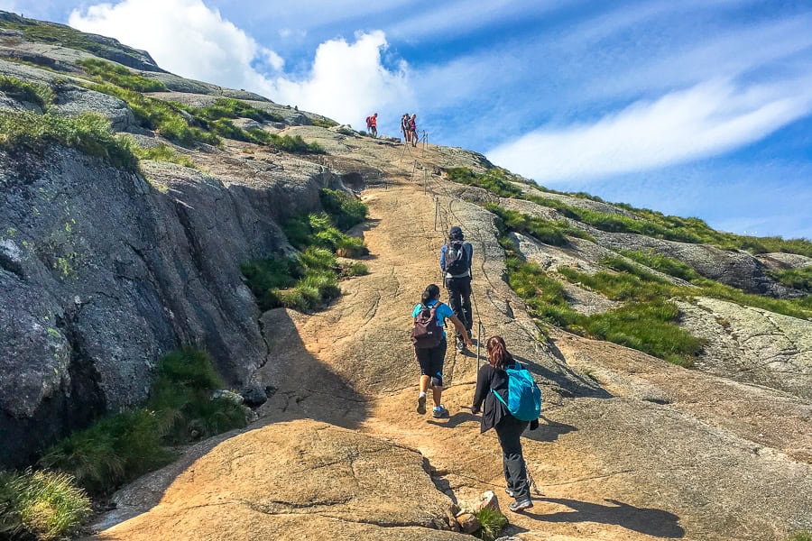
Kjerag is a challenging hike with rocky, uneven ground and a number of sections where chains are bolted to the rock to help hikers get up and down the steeper inclines. A reasonable level of fitness is a must.
It took us around two hours each way, and we spent around two hours at the Kjeragbolten ‘summit’ (which included half-an-hour of queuing each to get on the boulder itself).
The Kjerag hiking trail
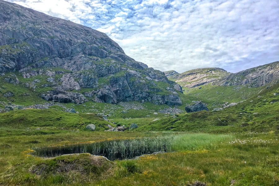
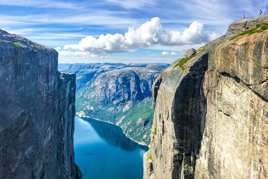
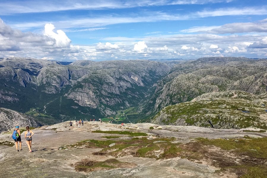
The Kjeragbolten hike is an out-and-back trip just shy of 10 kilometres that traverses the Lysefjord in south-western Norway. It gains around 800 metres in altitude along ever more challenging climbs.
The hike starts with a tough, steep climb right out of the car park, followed by a short plateau and another climb. This pattern repeats three times before you reach the plateau leading to Kjeragbolten.
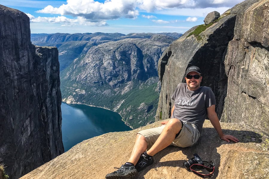
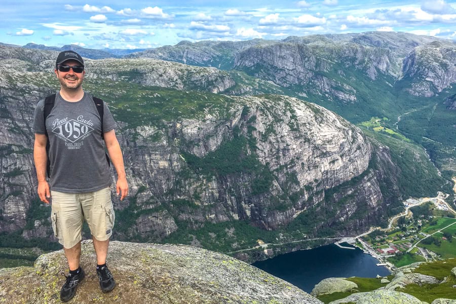
The final approach is a relatively flat, rocky stretch leading to the boulder. The Kjeragbolten is a large boulder wedged in a gap between two sheer cliffs with a near-1,000-metre vertical drop below. Stepping onto it is optional and entirely at your own risk – there are no safety rails.
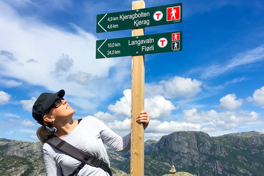
There are a few trail options to hike Kjeragbolten, in addition to the out-and-back trail we took and which we’ve profiled here. For more about the hikes, including maps and reviews, head to AllTrails’ best trails near Kjeragbolten page.
Kjerag has been designated a Norwegian Scenic Hike by the Norwegian Environment Agency. The designation recognises the outstanding natural beauty, environmental sustainability, and overall management of the trail.
Trail conditions
The hike to Kjerag is demanding, with rocky paths, steep climbs, and sections where we needed to scramble. The trail is well-marked with red T’s, but uneven and slippery surfaces, especially when wet, make careful navigation essential.
There are three distinct climbs along the trail, involving increasingly steep ascents where you’ll need to use chains to scramble up and down the steep slopes.
It’s also worth emphasising that there are no water refill points or toilets on the trail, and it is very exposed to the elements.
Facilities
There are limited facilities at the Kjerag trailhead and none on the trail itself, so it’s important to come well prepared.
There are no water refill points or bins on the trail, so bring enough water, carry out all waste, and pack everything you’ll need for the day. Once you leave Øygardstøl, there are no further facilities until you return.
Parking: There are two parking areas at Øygardstøl, with a capacity for up to 400 cars. The car parks are open 24 hours and have automatic gates with licence plate recognition. We’ve seen a few complaints about the NOK 300 fee to park for the day, however the money helps fund the toilets, tourist information and wifi, which can all be costly in such a remote location.
Café: There’s a café/restaurant at the trailhead offering hot and cold drinks, snacks and light meals during the main hiking season.
Toilets: Toilets are available at the carpark but there are no facilities along the trail itself.
Tourist Information: There’s a small tourist information office next to the toilets that also has free wifi if you need it.
Safety tips for hiking Kjerag
As with any mountain hike, be ready for changeable weather and wear decent walking shoes when hiking Kjerag. Depending on the conditions (and your level of fitness) it can take anything from four to six hours to hike the trail, so make sure you’re carrying enough food and water to get you through the day.
Weather conditions: It’s critical to check the weather forecast before your hike Kjerag. Conditions can change quickly here, and heavy rain, fog and strong winds aren’t uncommon. You can get advice on trail and weather conditions at the tourist information office at the Kjerag car park, and during the hiking season they also provide updates on their Facebook page.
Stay on the trail: To ensure your safety and protect the environment it’s important to stay on the hiking trail. You’ll find signs along the route as well as red ‘T’ signs painted on the rocks to keep you on the right path.
No barriers: While the views along the trail and at the summit are spectacular to the point of distraction, take care when you’re near the edge. This is particularly important when surfaces are slippery due to rain, snow or ice.
Emergency contact: In case of an emergency, call 112 (Police) or 113 (Ambulance). There’s mobile coverage on parts of the trail but it’s also a good idea to let someone know your plans before you head out on any hike.
There’s also an emergency shelter at the top of the second climb.
Our experience hiking Kjerag
Journey to the trailhead
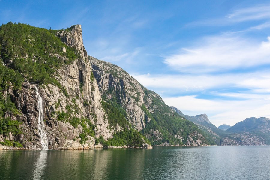
Our day trip to Kjerag started bright and early with a captivating 42-kilometre ferry ride from Lauvvik through a rugged, weather-beaten, glacier-carved landscape formed during the last ice age.
Cruising past the immense waterfalls and high peaks of the Lysefjord, including the square, flat-topped peak of Pulpit Rock, another outstanding hike we’d done just a couple of days earlier, we made our way into the heart of fjord country.
Once off the ferry, drivers are put to the test on Lysevegen Road, a winding trail of tight mountain switchbacks considered to be one of the most perilous roads in the world. Or the most spectacular, depending on your perspective.
Hiking Kjeragbolten
We found the Kjerag hike quite tough, but when you’re high above Lysefjord taking in the expansive views all around, the hard work to get there is worth it.
The trail starts with a very steep climb for almost one kilometre right from the Øygardstøl car park. There’s a fixed chain to help you haul yourself up the smooth, rocky slope, but even with a reasonable level of fitness, we were pretty puffed by the time we got to the first small plateau after around 30 minutes.
We were extremely lucky we were here on a warm, dry day, and I can imagine the climb would be quite slippery and much more challenging in wet weather.
From here the trail levels out long enough for you to catch your breath and enjoy the already vast views, including towards an upcoming valley and, ominously, the second climb you’ll shortly be embarking on.
We enjoyed our recovery time as the trail dipped slightly before starting the second climb of around 600 metres – this one even steeper than the first – over large boulders and bare rock. We made use of the chain here to again get us to the top and a large plateau where we stopped for a snack and enjoyed the breathtaking scenery.
The third and final climb is a steep slog for around a kilometre over loose rock with more chains. Once you crest the ridge, the terrain opens out to a wide plateau with views across Lysefjord.
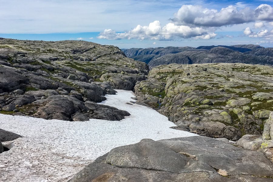
The trail then continues across a rocky, undulating slope, punctuated by stubborn patches of snow and glacier ponds for a couple of kilometres before you reach the famous Kjeragbolten boulder.
The Kjerag boulder
It’s hard not to be awed by Kjeragbolten, precariously wedged between two cliffs 984-metres above Lysefjord.
You may get lucky and have the place to yourself, but queues to step onto the boulder can build up in summer – we waited around 30 minutes when we visited in July.
While leaping on to the boulder is an unforgettable experience, plenty of people do the Kjerag hike without undertaking this daunting finale. For your own safety, it’s also really important to consider the conditions on the day before attempting to step onto the boulder.
For the record, the views from around the boulder are equally spectacular.
With or without the boulder dash, the achievement of the trek and the sense of awe you get from being in such a truly beautiful landscape makes the Kjerag hike an absolute highlight of a visit to this part of Norway.
The return follows the same route back, with the descents often feeling just as tough as the climbs.
Is stepping onto Kjeragbolten scary?
To be honest, I found queuing to step on to the famous Kjeragbolten to be the worst part, as it gave me too much time to actually think about it. Plus, as I would go on to discover, the final few steps to the boulder are along the barest stretch of path with rock on one side and a vertical drop on the other.
I remember standing in the queue, surrounded by people wearing their best nonchalant faces, waiting for their moment to leap onto the boulder. Or turn back.
When the guy before me opted for sensible and left the line, I’ll admit to being sorely tempted to follow. But with Danielle having already taken the big step, there was really no going back; I couldn’t very well give her sole bragging rights.
So there I was, near the front of the queue, trying desperately not to look over the edge.
By this stage I’d spent a good half-hour talking myself into it, and reminding myself that it hasn’t ended badly for anyone – at least that’s what I’m told.
Then there was just one person in front. They weren’t in any hurry and seemed to actually be enjoying their moment on the boulder. For me, watching them just allowed the doubts to creep in again.
Then it was my turn.
Taking two steps forward, I grabbed the metal hook in the rock face with a trembling, sweaty forefinger, edged myself around a corner a couple of feet wide, trying not to look at the thousand-metre fall below, before taking one final deep breath, and a half step, half jump onto the boulder.
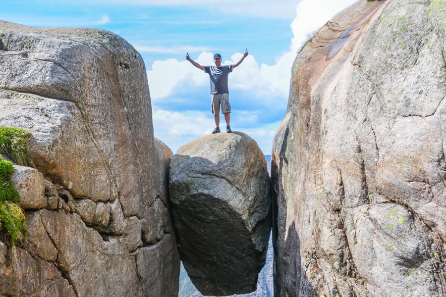
I vividly remember that moment atop the boulder, jelly-legged, trying my best to strike a pose and appear confident atop this metre-wide hunk of rock precariously suspended above the fjord.
But in reality, for me at least, it was a gut-churning, leg-shaking, ever-so-slightly nauseating, and utterly terrifying experience. That said, I don’t regret it for a second. I’m just relieved I kept the contents of my stomach where they should be.
Whether you take on Kjeragbolten or just take pics, the Kjerag hike is a spectacular trail that you’ll always remember.
Kjerag Tours
Guided hiking tours
While many people hike Kjeragbolten independently, a guided tour is a great option if you’re interested in the expertise and insights of a hiking guide, if you don’t have your own transport, if you like hiking as part of a group, or feel nervous about taking on a more challenging hike like this one.
With return transport from your accommodation in Stavanger, this small group guided hike will help get you up the mountain with patient, experienced guides and a friendly atmosphere. They get great reviews from other travellers.
If you’re an experienced hiker looking to visit Kjerag out of season, there’s a well-reviewed off-season tour option available. Again, it’s a small group tour, including transport there and back from Stavanger, and a packed lunch to be enjoyed at the Nesatind viewpoint. This is a unique opportunity to experience the trail outside the traditional hiking season, with ice and snow on the trail earlier in the year and warm, Autumnal colours later in the year.
Non-hiking options
You’ll be happy to know there are plenty of water-based options available if you’re keen to see Lysefjord but aren’t up for the challenge of hiking Kjeragbolten. There are a couple of extremely popular options with decent reviews that stand out from the crowd:
- Scenic Fjord Cruise to Lysefjord and Preikestolen: This half-day tour from Stavanger on a silent electric boat will take you from the city all the way up Lysefjord to Pulpit Rock. The tour includes an audio guide, while the boat has a kiosk for snacks, and toilet facilities.
- Lysefjord Sightseeing RIB Boat Tour: Departing from Stavanger Harbour, this RIB boat tour takes you up Lysefjord to see Pulpit Rock, Vagabond Cave, Whisky Falls and more. Trips are around two hours and include a guide.
Whether you decide to hike independently, join a guided hike, or cruise Lysefjord, in our opinion, a day trip to Kjerag easily ranks as one of the best things to do in Norway.
While the hike is a challenging one, you’ll be rewarded with sweeping fjord views, dramatic mountain landscapes, and the chance to see (or stand on) the iconic Kjeragbolten.
It’s a day trip where you’ll experience Norway’s wild beauty in all its glory, and we’d highly recommend including it on your itinerary for Norway.
We hope you enjoy your Kjerag hike. If you’ve got any questions or comments, drop us a message below. If you’re interested in hiking more in the area, check out our Pulpit Rock guide.
If you’re visiting Norway for longer, check out our Norway road trip itinerary and Norway page for travel inspiration and Ideas for this incredible corner of Scandinavia
Holy moly, this made my palms sweat! What an amazing feat!! Good on you for not backing down! Epic photo, love your blog, guys!
Hey Lisa, thanks for the comment and the lovely feedback on the blog. It was indeed an absolutely epic experience that we’d highly recommend. Any plans for you and Sasha to head to Norway? Can’t say it’s the most exciting culinary destination we’ve ever been (although it does have some unique offerings), but it more than makes up for it with huge landscapes and amazing hikes.
Great Blog again guys – just one question – how do you get back off it?
Thanks Neil! Getting off the boulder? Same way you get on – one small leap for everyone watching, one giant leap for the nerve-wracked person on the rock, lol. As for getting back down the trail, there’s always BASE jumping. Fastest way down. We weren’t tempted. ?